CHENNAI: An undersea landslide near the Andamans, followed by an earthquake near Sumatra, is believed to have powered the tsunami waves that slammed into India’s coast in 2004, killing more than 10,000 people.
Such landslides, however, do not always need an earthquake to trigger them.
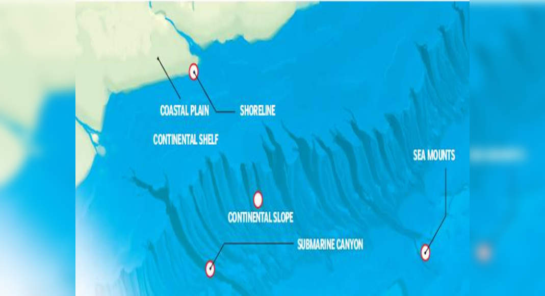
Recently, Indian researchers mapping the seafloor in India’s exclusive economic zone (EEZ) along the Palar Basin off Chennai found landslide areas and identified landslide susceptible zones capable of causing tsunamis.
They also mapped cracks on the continental slope that are precursors to landslides and at least 20 canyons or valleys, evolved from landslides, with plunge pools and mega dunes just 30km from the coast.
Many of these features, unique to the steep Palar region, are potential geohazards that could cause offshore and onshore destruction.
They were identified for the first time by scientists of National Centre for Polar and Ocean Research (NCPOR), Goa as part of decade-long efforts to survey and map the seafloor in the EEZ to identify regions of living and non-living resources like metals, minerals and fish as well as to improve accuracy of tsunami forecast models.
India’s EEZ extends to 200 nautical miles (370km) from the coast and up to 3km depth along the 7,500km coast.
NCPOR scientist P John Kurian, corresponding author of two papers on the morphology of seafloor in Palar Basin, said cracks often precursors to landslides may have developed due to a slip or movement of rocks on either side of a fault or due to dissociation of gas hydrates in marine sediments.
Landslides could have been triggered by factors like high sedimentation, slope over-steepening, gas hydrate dissociation, tectonic activity or sea level changes.
Canyons are an extension of the Palar’s tributaries carrying sediments to the deep sea.
“We need high resolution mapping and carbon dating of sediment cores to find out the exact time it took for these features to form,” he said.
It is believed that sediment resting over a glide plane (surface on which sediment can move) along the continental shelf break (where the continental slope begins) is susceptible to down-slope slumping under a trigger like earthquake, sediment overloading, fluid migration, turbidity currents and storm surges.
“The potential risk of a landslide induced tsunami in such cases depends on the volume of slumped material in one go,” he said.
The Palar Basin, covering 3,500 sq km, is between 300m and 3,300m deep; and the continental slope has a gradient ranging from 3 to 78 degrees.
With a multibeam sonar and a sub-bottom profiler, scientists mapped a series of cracks on the continental shelf-slope region, many as deep as 130m and 10km long.
One of the widest, observed along with a sediment slump, was 1.6km.
At least five landslides were spotted where the landslide mass may have disintegrated over time or was buried by subsequent sedimentation.
These disintegrative landslides had slopes or scraps with an average width of 2.7km and length of 1.25km.
The team also identified three landslide-susceptible zones around 30km from the coast based on cracks and failures or movement of sediment on the slope.
The closest of the 20 canyons was 45km from the coast, had a maximum length of 19.1km and 3km deep.
“The landslide susceptible zones on the continental slope we identified need to be validated with high-resolution seismic reflection data and a geotechnical analysis is required to determine the stability of the slope, which is important for geohazard assessments,” Kurian’s papers said.
On the west coast, scientists found seamounts which are regions of potential mineral and fish resources that NCPOR researchers would study in future.
NCPOR director Ravichandran said mapping the seafloor on the EEZ would help identify locations of resources like minerals and fish, while also helping finetune tsunami models.
“We have been mapping the seafloor for a decade now.
We have mapped more than 90% of the area above 500m depth and work is on to map shallow water depth, which is difficult because we could only map comparatively smaller areas at one go.”
Researchers find landslide-prone zones that cause tsunamis